
This topic explains the underlying logic of the topological ordering algorithm used within the NextGen Platform. By understanding how this algorithm maps and connects geographical points, planners can better appreciate how the system automatically optimizes the sequence of inspection tasks along linear assets (such as power lines, railways, or pipelines), ultimately minimizing field technician travel time and improving route efficiency.
This conceptual logic powers the "Topological" ordering option available when reorganizing operations within a Work Order Bundle from the Bundle detail.
How the Algorithm Works
When you apply a topological ordering rule to a bundle of operations, the algorithmic engine performs a series of spatial calculations to create a continuous, logical route. The process follows three core principles:
-
Reconstructing the Structure: The algorithm maps the linear asset's physical structure using the geographic coordinates of its individual points and segments. The system considers two points to be "connected" if the distance between their endpoints falls within a specific, system-configured proximity threshold.
-
Determining the Sequence: Once the structure is mapped, the sequence of WO operations is dictated by following the natural linear continuity of the asset's segments.
-
Selecting the Next Segment: When the algorithm reaches the end of one segment and must choose where to go next, it evaluates all connected (or nearby) segments. It selects the next segment based strictly on proximity—specifically, the segment with the closest available starting or ending point to the technician's current location.
Use Case
To illustrate this, imagine a linear asset broken down into four distinct segments: A, B, C, and D.
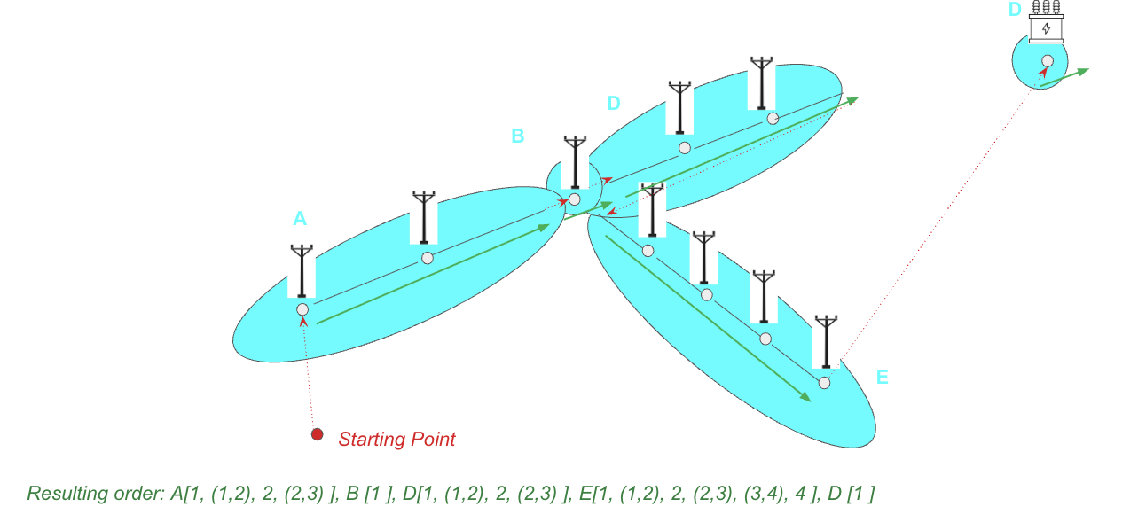
Here is how the algorithm processes the inspection route:
-
Establishing the Starting Point: The algorithm requires an initial anchor. This is typically a designated starting coordinate (often provided by the user when applying the rule) or the geographic location of the first operation near segment A.
-
Navigating the First Segment: The engine routes the inspections sequentially along segment A, adhering to its linear continuity. For instance, it might order the tasks as: Start of A → Point 1 → Segment (1,2) → Point 2 → Segment (2,3).
-
Bridging to the Next Segment: Upon reaching the end of segment A, the engine evaluates its surroundings based on the configured distance threshold. If segments B and D are both technically "connected" to A, the algorithm calculates which segment has a starting or ending point geographically closest to the end of segment A. If segment B's start point is closer, it becomes the next stop.
-
Continuing the Route: After mapping all operations along segment B, the algorithm repeats the proximity evaluation, likely moving to segment D next, ensuring the technician follows an unbroken, highly efficient path without unnecessary backtracking.
Note on Extensibility: While the foundational algorithm relies on geographic proximity and linear continuity, this logic is designed to be extensible. Future configurations can incorporate secondary routing criteria, such as weighing the shortest estimated duration of the next segment or prioritizing segments containing the highest density of critical operations.
Related Content